2016 Barlow Travel Grant Report
By Allyson Maynard ’00
Background
The 2016 Barlow Grant funded my trip to Iceland in July and August 2016. As an earth science teacher, I have long considered Iceland a near-mythical place, given its location atop two spreading tectonic plates. The ways that the earth systems and human systems interact and overlap in Iceland hold an additional appeal, as I am currently living in Boise, Idaho, whose downtown has had geothermal heating since 1892 — and where a geothermal greenhouse can grow citrus fruit year-round. While Boise and the U.S. are nowhere close to Iceland’s high degree of renewable energy use, the potential for more is lies a short way down the road from my house. I was interested in traveling to Iceland to immerse myself in a landscape shaped by the earth’s underground forces, to learn more about tapping into renewable energy sources, and to explore how the story of the landscape interacts with and influences the lives of the Icelandic people.
Trip Report
Overall, my trip was divided into three sections: backpacking in the Hornstrandir Nature Preserve, exploring and car camping around Iceland’s Ring Road, and investigating the museums and resources of the capital city, Reykjavík. The time spent in Hornstrandir was perhaps the most impactful; it held some of the most beautiful, rugged, and remote backpacking terrain that I have ever experienced.
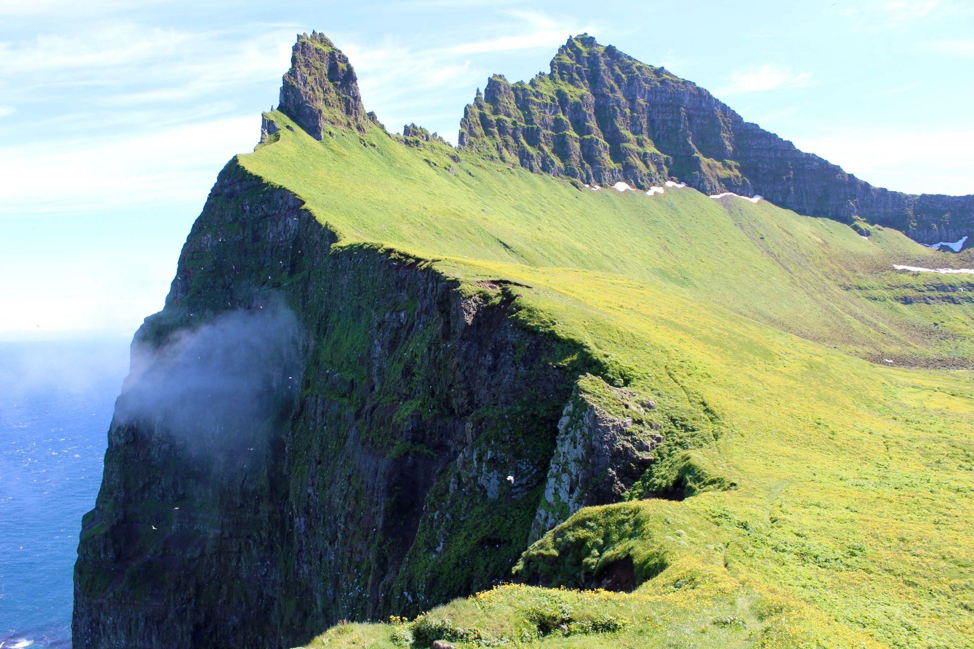
The Hornstrandir Nature Preserve in the northwest corner of Iceland holds some of the most beautiful, rugged, and remote backpacking terrain that I have ever experienced.
This first leg consisted of a flight from Boise to Boston, Boston to Reykjavík, and from there an in-country flight to Ísafjörður in the Westfjords. The following morning a small boat took us across to the tip of a long fjord, where a few of us hikers were dropped off in the tidal area by Zodiac raft. For the next four days, I would hike through rain and snow, sunshine and clouds. My gear was tested, the views were ever-changing — from mountainous to coastal and back again — and the sun never fully set. I frequently exclaimed, usually to no one in particular, that it was the most beautiful place I had ever seen. I was visited by Arctic foxes, the only mammal native to Iceland, and saw many species of bird, especially at the Horn at the tip of the peninsula. There was water everywhere: falling from the sky at times, rushing down steep cascades, and just pouring out of the hillsides. Because of the natural filtration of the porous volcanic rocks, we were told that purifying water wasn’t necessary, so we drank spring water from our campsites, something that I can never really do while hiking in the States. After descending across a large snowfield, and down into the small seasonal community of Hesteyri, I enjoyed a plate of crepes/pancakes at the Doctor’s House (a must-do, I was told) and set up for one last night before the boat returned in the morning. Reading about the Hornstrandir Nature Reserve that night, I found myself incredibly thankful that the preservation guidelines for this area have thus far been enough to keep it wild, with fairly minimal evidence of human impact. As tourism in Iceland grows, and the word about this area spreads, I hope that safeguards will be implemented to maintain the quality of wild that I experienced.
The second leg of this trip involved back-tracking to Reykjavík for a car-camping drive around the Ring Road, roughly 800 miles of mostly paved “highway” circling the entire country. Because the vast majority of visitors to Iceland stick to Reykjavík and the nearby Golden Circle, I hoped to find some quiet away from the most heavily touristed areas. While there were certainly plenty of travelers along parts of the drive, there were also many areas where there were few amenities, few tourists, and even fewer tour company vans and buses. This route took me by waterfalls, glacial fjords, coastal cliffs, rolling green hills, and countless grazing sheep. There were many times when it felt as though I was on the set of an epic movie — the scale of the landscape, rife with green vegetation and the stark beauty of lava fields, was immense. One experience that stands out to me is my visit to Vatnajökull National Park. A popular destination for day trippers looking to walk to the tongue of the glacier, Vatnajökull was created in 2008 and covers about 14 percent of Iceland; it is one of Europe’s largest national parks.
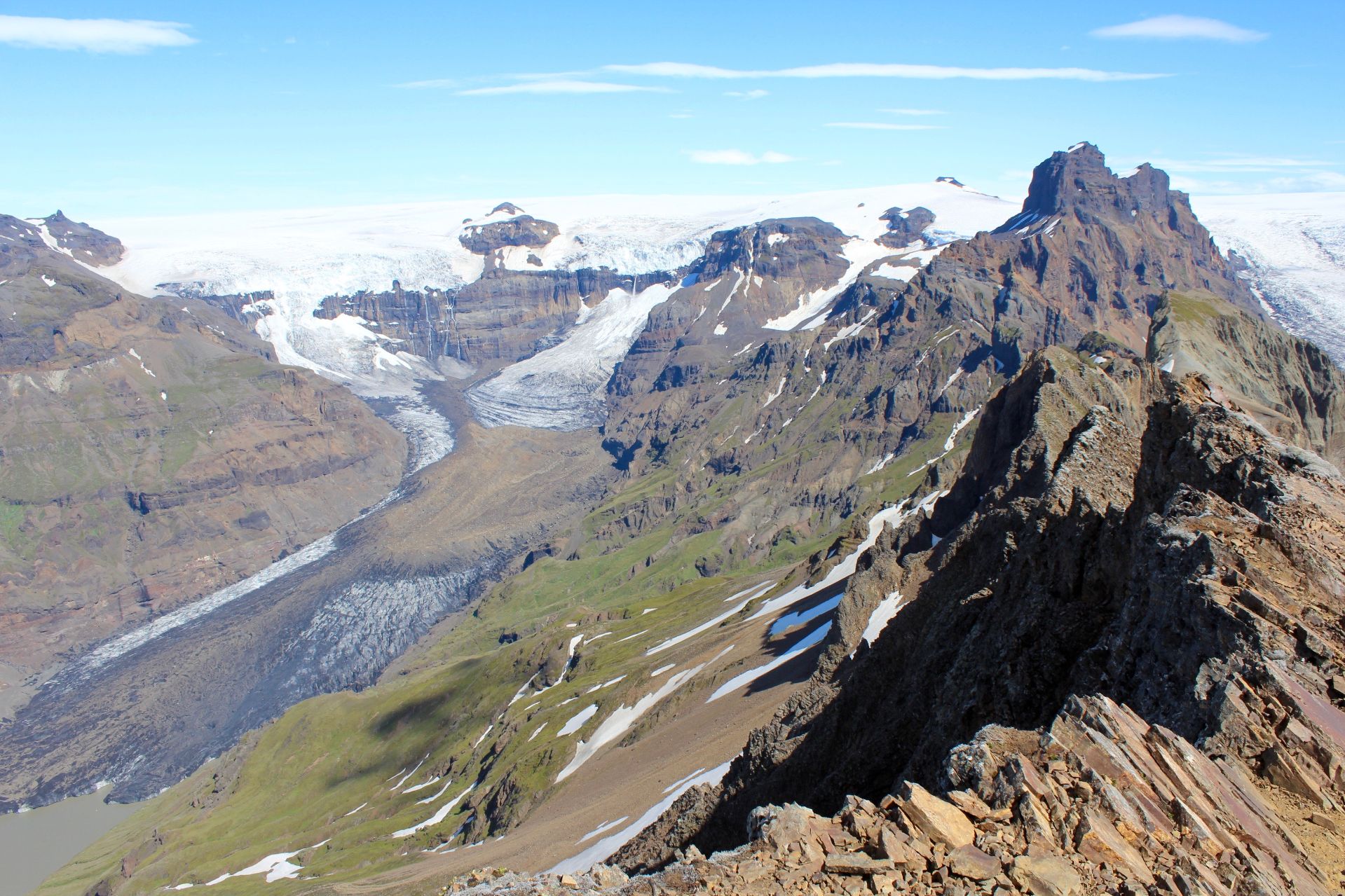
The view from one of the summits in Vatnajökull National Park, which covers about 14 percent of Iceland and is one of Europe’s largest national parks.
I found that it only took about 45 minutes of hiking to leave behind almost all other park visitors. Beyond Svartifoss, the black basalt waterfall, I saw only three other hikers the entire day, which was a stark comparison to the hundreds down below at the visitor’s center. This hike, which traverses a moor, up a steep and sharp peak with stunning glacial views, and back along a plateau to the cliffs above the glacial tongue, offered views into the vast and mountainous inner region of Iceland. To say it was stunning is an understatement. What was most striking to me was knowing that beneath the ice and snow spreading out all around me were some of Iceland’s largest and most active volcanoes. The nickname “land of fire and ice” is incredibly appropriate and good to remember when standing with such a broad view of the southeastern part of the country. Not far away from where I hiked was the Eyjafjallajökull volcano, famous for its 2010 eruption that disrupted air travel for nearly a week.
Comprising an area about the size of Ohio, Iceland astounded me with its varied landscapes. From desolate lava fields, to small coastal fishing villages, to the foggy Highlands, the views were different every day and in every region. Some places appeared untouched by the increased tourism that Iceland has experienced in the past 15 years, while others show signs of growth from increased efforts to entice visitors. There were small, roadside shops selling traditional sweaters, and many small towns had hostels or campgrounds to support travelers such as myself. As I looped around past the thermal pools of Mývatn and skirted the northern fjords, I saw Icelandic ponies trotting with their iconic gaits and sheep sporting their equally distinctive wool. There were bubbling hot springs, volcanic craters, and cliffs so buffeted by wind coming off the water that car doors had to be opened with great care, so that they weren’t torn out of my hands.

Geothermal venting, seen here near Mývatn, is evidence of the fire not far below Iceland’s surface.
Coming back into Reykjavík, I made one side trip that had been on my science-teacher bucket list for some time. Although not the most remote or visually stunning location, Þingvellir National Park will remain one of my favorite sites. Here, I was able to stand in the exact place where, for as much as two centimeters each year, two major tectonic plates are spreading apart. Although it has great historical significance as the site of early Viking democratic parliament meetings, I was focused the geology of the area: the crumbly plate edges, the pathway running atop the more recently cooled surface, the view toward North America to one side and Europe on the other. Standing there, a foot on each plate, I contemplated the ever-widening rift and could see evidence of it directly below my feet. A very cool day for a science teacher!

In Þingvellir National Park, I could stand atop two major tectonic plates that are spreading at a rate of two centimeters each year — a very cool day for a middle-school science teacher!
While in the city, I also took the opportunity to explore some of the nearby geothermal and geological sites. Touring the Hellisheiði geothermal power plant gave me insight into the commitment that Iceland has made to realizing the full potential of geothermal energy. Pipes running along the road from the plant back to the distribution center in Reykjavík are so well insulated that the water loses only a few degrees even after traveling 25 kilometers. One of the world’s largest this geothermal plant produces much of Reykjavík’s hot water and contributes to production of Iceland’s electricity, the majority of which is produced at hydro-power plants. The underground geothermal pipes in the newer parts of the city keep the sidewalks clear of ice and snow in the winter. Greenhouses are able to tap into the underground geothermal heat to provide fresh produce year-round. While the city of Boise, Idaho, also uses geothermal heat by running pipes through many of the downtown buildings to regulate temperature, we definitely do not have heated sidewalks. It sounds like a brilliant idea.
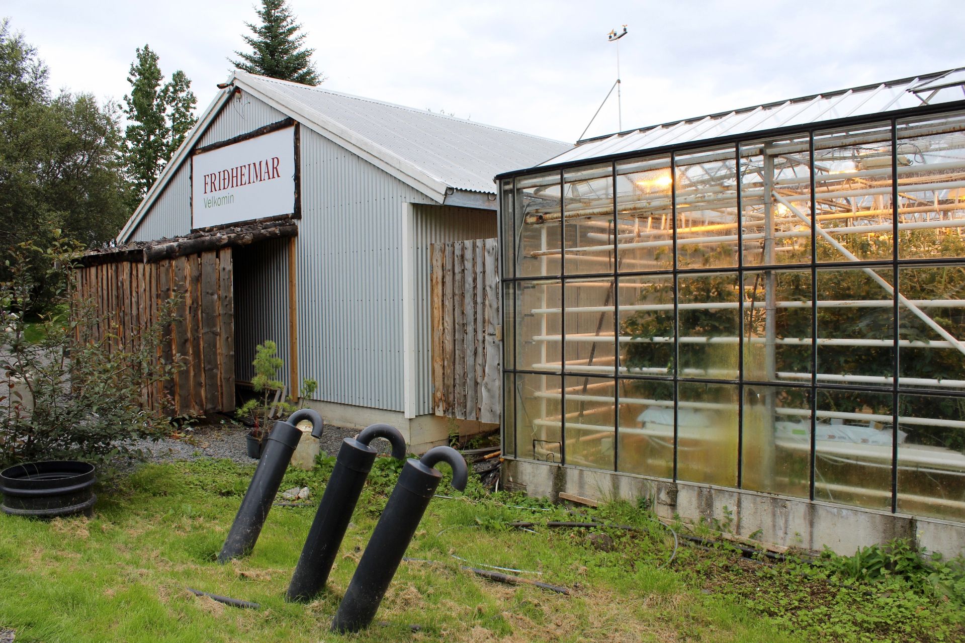
Buried underground, geothermal pipes in the newer parts of the city keep the sidewalks clear of ice and snow in the winter. And greenhouses like this one tap into the geothermal network to provide fresh produce year-round.
Wrapping up my visit, I spent a day traveling to the Sólheimajökull glacier in the southwest part of Iceland. While I don’t usually like to join guided tours, I knew there was no other way to traverse the glaciers, and I found that the group experience pleasant after my solo adventuring in Reykjavík. Outfitted with warm clothes, helmets, crampons, and ice axes, our group ascended to the edge of the tongue of the Sólheimajökull glacier. Here, we saw glimpses of the mesmerizing blue found only at the freshly melted edges of glacial ice. Up close, much of the surface was covered with dark ash, remnants of the 2010 Eyjafjallajökull eruption.
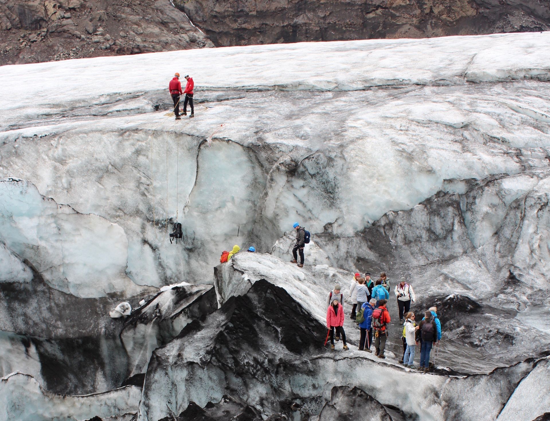
Crampons and ice axes were required for our group hike to the edge of the tongue of the Sólheimajökull glacier. Much of its surface was covered with dark ash from the 2010 Eyjafjallajökull eruption.
Reflection
The bits and pieces that I have shared here barely touch the surface of what I saw and accomplished while on this Barlow Travel Grant-funded trip. I am deeply appreciative to have had the opportunity to travel and explore so extensively, and I returned to Boise and to my classroom filled with firsthand accounts of the places that I teach about each year, which will rejuvenate several of my students’ learning activities and projects.
In thinking about this trip and the gratitude that I feel toward David Barlow ’79 for creating this endowed fund, I came to an important realization. While I’m now a frequent hiker, finding myself on trails in all seasons and in many mountain ranges, I took my first steps with a fully loaded backpack on my AESOP trip, as a first-year student in 1996. That three-day adventure with my new Bates classmates led me to find community in the Outing Club, which led me to develop a love for the outdoors, which, in turn, led me to study environmental science and, ultimately, a career teaching science. It was on day three of my hike in Hornstrandir with a pack on my back that I realized the unbroken connection between my first steps with AESOP and these steps in Iceland. Thank you, Bates, for blazing the path.
After teaching seventh-grade science in southern Vermont and Maine, Allyson Maynard ’00 joined the faculty at Anser Charter School in Garden City, Idaho, as middle school science teacher in 2012. She earned a bachelor’s in child and family studies at Bates and a master’s in environmental studies with teacher certification in middle grades science at Antioch University New England. Aside from teaching, she enjoys getting to know new places and experience new landscapes through hiking, Nordic skiing, and kayaking.
Apply for the Barlow Alumni Travel Grant